As the speed of constructing smart cities increases, automatic control and management of municipal facilities become more and more necessary. In the past, the usual technique for controlling street lights was to use a timer clock or physically manipulate the switch. The street lights sometimes cannot be switched on and off consistently, and there is a lack of corresponding detection means. So GIS technology becomes a way to solve this problem. Let’s dive in to find out how the GIS smart street light system works!
How is the GIS smart street light system built?
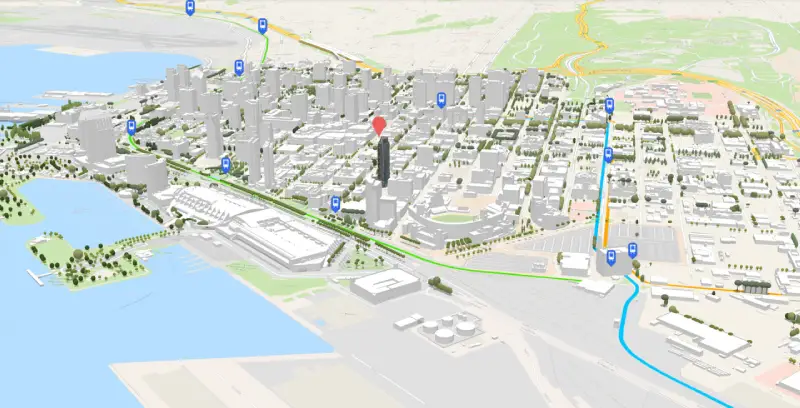
On the one hand, create an automated geographic information system for urban street lights using GIS visualization. Its content comprises the generation of visual loss graphics such as basic geographical information for cities, blocks, and street light distribution. Thus, it provides a support platform for visual query, dynamic display, and monitoring for street light control management.
On the other hand, create a management module for central control. The central control and management module is based on GIS visualization and a LAN operation platform. The central control management module can provide a set of dynamic display functions based on GIS for visualizing the status of street lights. Besides, the dynamic database will update based on the detection of real-time light information. This allows for intuitive monitoring of dynamic information on light conditions via graphics. Visual querying and database management of the lighting status database are also easy to achieve with GIS.
How does the GIS smart street light system work?
The system is made up of four procedures: hardware basic perception, network communication, cloud service platform management, and terminal control.
The hardware basic perception part consists primarily of street lamps, controllers, sensors, and so on. Once connected, these terminal hardware devices sense the surrounding environment and street light status. Then they communicate with the transmission network to receive and transmit intelligent control information.
The communication network includes methods like PLC power network, ZigBee, 3G/GPRS, 6LoWPAN, RS232/485, and other wireless or wired means. The transmitted data is stored in the street light Internet of Things database, which integrates data from various terminal sensors and enables distributed and centralized data management.
The cloud service management platform can monitor and dispatch street lights as well as manage operation and maintenance data. Using GIS maps, the cloud service management platform can quickly locate various sensing devices. Following that, it can carry out information retrieval, statistics, and equipment management.
For control terminals, there are many types. Managers can use them to send control instructions to the cloud platform in order to realize various functions of smart street lights.
What can GIS smart street light system do?
In the data layer, the system can collect various types of data. The underlying data set includes basic geospatial data, urban lighting facility data, and business management data. In the basic geospatial database, there is information about administrative divisions, road networks, buildings, and, if conditions permit, remote sensing image data. The urban lighting facilities database includes static spatial information about these facilities, attribute information about them, etc. The business management database stores critical business data such as system operation and maintenance guarantees, equipment ledgers, and system management.
In the middle layer, data is processed for real-time monitoring. The middle layer consists primarily of a geographic information platform, GPRS monitoring, and video monitoring services and interfaces. Through these services and interfaces, corresponding businesses can be implemented. Simultaneously, it provides the technical means for data calls between systems.
In the presentation layer, the system can realize control and management. This layer is the user interface of the street light integrated management system. It includes the basic information management module for street lights, the GIS operation module, the monitoring data management module, the video monitoring module, and the ledger statistical report module. It can not only perform traditional monitoring operations, but it can also visualize space-based road data and perform spatial query and retrieval operations.
Conclusions
In this passage, we talk about the composition of the GIS smart street light system, how it works, and what it can achieve. We can create an automated geographic information system and a management module for central control with GIS. And then the whole process will be finished through hardware basic perception, network communication, cloud service platform management, and terminal control. The functions of GIS are collecting various types of data, monitoring, and controlling for different purposes. While used in smart street light systems, GIS can definitely do more than simply locate where things are!